Shortcut: wd:WDQS/Result views维基数据:SPARQL查询服务/维基数据查询帮助/结果视图
.png)

.png)

此页面有助于了解可能显示在SPARQL查询服务上的结果。
查询示例页面有很多值得尝试的例子!
Open the WDQS interface and then:
- select your language in
 of the upper tool bar.
 - write a valid SPARQL code in the text area.
- check your script by hovering the elements with your mouse; tooltips appear and should be consistent with what you intend to do. They adopt the language you have selected (default to english).
- then click on blue button Execute query of the sidebar to launch the request. Red square is lit in the sidebar while the command executes.
- 运行一笔查询后,可以选择“显示”来选择要显示的结果视图。视图根据查询和数据类型而有所不同。
| Source example |
|---|
# Recent events
SELECT ?event ?eventLabel ?date
WHERE
{
  # find events
  ?event wdt:P31/wdt:P279* wd:Q1190554.
  # with a point in time or start date
  OPTIONAL { ?event wdt:P585 ?date. }
  OPTIONAL { ?event wdt:P580 ?date. }
  # but at least one of those
  FILTER(BOUND(?date) && DATATYPE(?date) = xsd:dateTime).
  # not in the future, and not more than 31 days ago
  BIND(NOW() - ?date AS ?distance).
  FILTER(0 <= ?distance && ?distance < 31).
  # and get a label as well
  OPTIONAL {
    ?event rdfs:label ?eventLabel.
    FILTER(LANG(?eventLabel) = "en").
    }
}
# limit to 10 results so we don't timeout
LIMIT 10
|
Note: You can also run directly a hardcoded request via the TryIt links of this page. When it brings you directly to the result display you can always return to the source script unsing the link at the bottom of the interface.
表格(默认)
将结果显示为一个表格。这是默认的视图,可显示每一种数据类型。
Will map every variable from the SPARQL select clause to a formatted table column.
-
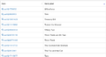 Table Result
 -
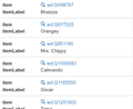 Table Result on small screens with flipped columns


图片格子

Shows the result data as a grid with images.
Every grid item has a big picture and opens the gallery when clicking on it.
Contents an item is the formatted row data.
| 变量 | 数据类型 | 呈现为 | 描述 |
|---|---|---|---|
| * | 共享资源媒体文件 | 单元格 | Image columns will create a grid item. |
不含图像的行将被忽略。
It’s nonetheless possible to include no image rows in the result by modifying the sparql by including a default image in case the image variable is not bound:
  optional {
    ?item wdt:P18 ?img_ .
  }
  bind (if(bound(?img_),
           ?img_,
           <http://commons.wikimedia.org/wiki/Special:FilePath/File:Profile_avatar_placeholder_large.png>) as ?image) # [[:commons:File:Profile_avatar_placeholder_large.png]] as a placeholder
Here the file commons:File:Profile avatar placeholder large.png is used as a placeholder, you can use your own.
选项
| 选项名称 | 类型 | 描述 |
|---|---|---|
hide
|
One or more variable names (strings, starting with ?), single value or array
|
Don’t show these variables in the result. |
地图
Shows the result data as map with OpenStreetMap data.
| 变量 | 数据类型 | 呈现为 | 描述 |
|---|---|---|---|
| * | 坐标或地理形态 | Map Marker | Columns will create a marker on the map.
Content of that marker is the formatted row data. |
| ?layer | Map Marker Layer | Creates a colored map layer that allows filtering. | |
| ?rgb | 颜色 | 彩色地图标记 | Example 000000 for black color. |


Technically, any well-known text literal can be displayed, not just a point coordinate.
Non-point geometry values are never stored on Wikidata, but they can be constructed in SPARQL using functions like CONCAT() and STRDT() –
see this map of Czech railway lines for an example of LINESTRING() geometry.
选项
specify using e.g. #defaultView:Map{"hide":["?foo", "?bar"],"layer":"?bar"}, using an array when there are multiple variables.
| 选项名称 | 类型 | 描述 |
|---|---|---|
hide
|
One or more variable names (strings, starting with ?), single value or array
|
Don’t show these variables in the result. |
layer
|
One or more variable names (strings, starting with ?), single value or array
|
Use these variables for the map layer, instead of the default ?layerLabel, ?layer.
|
markercluster
|
布尔值或对象 |
|
折线图、条形图、散点图和面积图
显示这些图表类型中的一种。
| 变量 | 数据类型 | 呈现为 | 描述 |
|---|---|---|---|
| * | 数字
标签 日期时间 |
X轴
Y轴 |
First will be X-axis, second Y-axis |
| * | 标签 | Category / Legend Item (optional) | Will only be used after the above are mapped |
| * | 标签 | Storyboard / Animation (optional) | Will only be used after the above are mapped |


Bubble Chart

Shows a bubble chart where the size and the color of the bubble can configured.
When an item is provided a bubble is linked to Wikidata.org.
| Variable | 数据类型 | Mapping |
|---|---|---|
| * | Label | Bubble Label |
| * | Number | Bubble Size |
| * | Item | Bubble Link (optional) |
| ?rgb | Color | Bubble Color (optional) |
Tree Map

Shows a zoomable tree map.
| Variable | 数据类型 | Mapping | 描述 |
|---|---|---|---|
| * | Label | Label | 1st label in a row will be 1st level in tree map. 2nd label will be 2nd level. 3rd label will be 3rd level etc.. |
| * | Item | Link (optional) | |
| * | Quantity | Size |
樹
显示为一个可展开的树状结构。

| 变量 | 数据类型 | 呈现为 | 描述 |
|---|---|---|---|
| * | 项 | 节点ID | First item will be a root node the following items in the same row will be nested. |
| * | 标签 | 节点标签(可选) | 标签文本将追加在当前节点。 |
| * | 数字 | 节点标签(可选) | |
| * | 共享资源媒体文件 | 项的图像 |
Timeline

Shows a explorable timeline.
| Variable | Data Type | Mapping | 描述 |
|---|---|---|---|
| * | DateTime | Item Point in Time
Item End Point in Time |
First date in a row sets the item position in the timeline.
If a second date is present a start and end date will be set. |
| * | Commons Media | Item image |
选项
| 选项名称 | 类型 | 描述 |
|---|---|---|
hide
|
One or more variable names (strings, starting with ?), single value or array
|
Don’t show these variables in the result. |
Dimensions

Shows dimension and their links.
It also allows filtering them by selecting an axis fraction.
This type of graph is also known as parallel coordinates.
| Variable | 数据类型 | Mapping | 描述 |
|---|---|---|---|
| * | Label | Dimension | Every column in the result row is mapped to a dimension |
| * | Number | ||
| * | DateTime |
Graph
Shows an interactive graph that allow hierarchically ordering and exploring items.
| Variable | 数据类型 | Mapping | 描述 |
|---|---|---|---|
| * | Item | Node ID | First item in a row of output variables will have an arrow pointing to the items in the same row. |
| * | Label | Node Label (optional) | |
| * | Commons Media | Node Image (optional) | |
| ?rgb | Color | Node Color (optional) | Color of the item just before the rgb variable. Example 000000 for black color. |
| * | Number | Node Size (optional) | |
| ?edgeLabel | Label | Edge Label (optional) |
-
 Graph
Graph -

Additional Information
RDF Data Type Mapping
| RDF Type | RDF 数据类型 | Constraint | 数据类型 |
|---|---|---|---|
| URI | String starts with http://www.wikidata.org/entity/Q |
Entity | |
| URI | String starts with http://commons.wikimedia.org/wiki/Special:FilePath |
Commons Media | |
| Literal | http://www.w3.org/2001/XMLSchema#dateTime | DateTime | |
| Literal | http://www.opengis.net/ont/geosparql#wktLiteral | Coordinate | |
| Literal | http://www.w3.org/2001/XMLSchema#double
http://www.w3.org/2001/XMLSchema#float http://www.w3.org/2001/XMLSchema#decimal http://www.w3.org/2001/XMLSchema#integer http://www.w3.org/2001/XMLSchema#long http://www.w3.org/2001/XMLSchema#int http://www.w3.org/2001/XMLSchema#short http://www.w3.org/2001/XMLSchema#nonNegativeInteger http://www.w3.org/2001/XMLSchema#positiveInteger http://www.w3.org/2001/XMLSchema#unsignedLong http://www.w3.org/2001/XMLSchema#unsignedInt http://www.w3.org/2001/XMLSchema#unsignedShort http://www.w3.org/2001/XMLSchema#nonPositiveInteger http://www.w3.org/2001/XMLSchema#negativeInteger |
Number | |
| Literal | 没有 RDF 数据类型 | Label | |
| Literal | Has property xml:lang |
Label | |
| Literal | String matches /^[0-9A-F]{6}$/ |
Color |
Formatting
对以下数据类型有特殊的格式化:
| Data Type | Format |
|---|---|
| Entity | Link to Wikidata.org
Label is shortened to wd:Qxx Explore an item (magnify icon) |
| DateTime | MM DD, YYYY
Tooltip shows raw ISO timestamp |
| Commons Media | Link to Commons.Wikimedia.org
Displaying Gallery ( image icon ) |
Mobile / Responsive
Result views are made to work on different devices and resolutions. Their appearance may change depending on the space they can use.
Embed Mode
Result views can be linked or embedded via iframes. You can get the regarding link or code by clicking Link in the above menu.
See the difference: link to a query and link to a result or the embed code:
<iframe style="width:80vw; height:50vh;" scrolling="yes" frameborder="0" src="http://tinyurl.com/zwf4k2w">
Download results

There are several ways to export the results of a query.
JSON, TSV and CSV are three different open-standard formats to download the data, offered under the Download tab. To get results in XML format, click on Link > SPARQL endpoint.
You can also download some of the graphic views as a SVG file: this feature works with all the views except table, image grid, timeline, graph builder, map, and graph.
Default View
The default view can be change for each SPARQL query by using a comment:
#defaultView:[NAME]
For example:
#defaultView:ImageGrid
Result view options
Result views can be configured with various options, which are specified in JSON (Q2063) format, either following the defaultView comment (see previous section) or following a separate view comment.
#defaultView:Map{"layer": "?typeLabel"}
#view:ImageGrid{"hide": "?coords"}
Title
Result views can show a title. The title can be set via a title comment.
#title:A title of your choice
List of WDQS tags
| WDQS tag | Display options | Notes |
|---|---|---|
| #defaultView:Table | Table | default format when omitted |
| #defaultView:ImageGrid | Image grid | |
| Graph builder | access to the graph builder tool | |
| #defaultView:Map | Map | |
| #defaultView:LineChart | Line chart | |
| #defaultView:BarChart | Bar chart | |
| #defaultView:ScatterChart | Scatter chart | |
| #defaultView:AreaChart | Area chart | |
| #defaultView:BubbleChart | Bubble chart | |
| #defaultView:TreeMap | Tree map | |
| #defaultView:Tree | Tree | |
| #defaultView:Timeline | Timeline | |
| #defaultView:Dimensions | Dimensions | |
| #defaultView:Graph | Graph | |
| #title: | title of the WDQS results frame | |
| #view: | equivalent to prefix #defaultView: |
Auto language
When using the magic keyword [AUTO_LANGUAGE] it is replaced by the users language when submitting the query. This allows writing a query with where the result is displayed in the users language.
Example:
#<span lang="en" dir="ltr" class="mw-content-ltr">Use language of the user for display labels and fallback to english as default</span>
SERVICE wikibase:label {
    bd:serviceParam wikibase:language "[AUTO_LANGUAGE],en" .
}
Auto coordinates
When using the magic keyword [AUTO_COORDINATES] it is replaced by the users location when submitting the query. This allows writing a query with the users' location.
Example:
  SERVICE wikibase:around {
    ?place wdt:P625 ?coordinate_location.
    bd:serviceParam wikibase:center "[AUTO_COORDINATES]".
    bd:serviceParam wikibase:radius "1".
    bd:serviceParam wikibase:distance ?dist.
  }