Wikidata:WikiProject Maps and atlases National Library of the Netherlands/Stedenatlas De Wit


This page is part of
- WikiProject Maps and atlases National Library of the Netherlands
- WikiProject Collection highlights National Library of the Netherlands
Both projects are part of the Wikidata efforts of the Koninklijke Bibliotheek Nederland
Stedenatlas de Wit[edit]
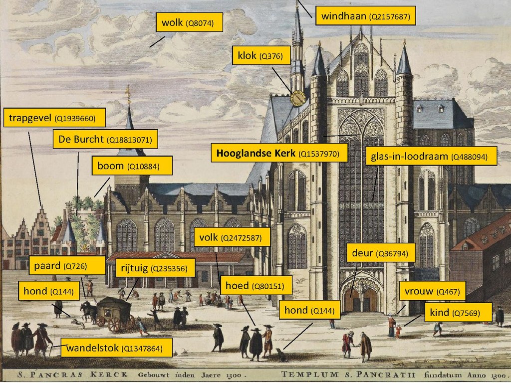
The Atlas De Wit (also: Town and city atlas De Wit) is unique, historic atlas by Dutch cartographer Frederick De Wit containing 158 city maps, city views and engravings from the northern and southern Netherlands (the current Netherlands, Belgium and French-Flanders).
More background information and city index (in Dutch): http://www.kb.nl/themas/atlassen/stedenatlas-de-wit
General[edit]
- Atlas De Wit 1698, collection KB (Q2520345)
- Commons category 'Atlas de Wit 1698'
- Description at KB.nl
Wikipedia[edit]
- Article Stedenboek Frederik de Wit exists on Dutch Wikipedia
to do[edit]
- Create article for 'Atlas De Wit' on English Wikipedia.
Experiments with semantic image tagging on Wikimedia Commons[edit]

The KB is undertaking some small scale experiments on Stedenboek de Wit to add P180 'Depicts' fields to selected images. In other words: the KB is exploring the added values of Wikidata based semantic tagging of things that can be seen (are depicted) im these atlas images. These Wikidata tags enable semantic searching for KB images in Wikimedia Commons and are the basis for further LOD functionalities that will be added to Commons.
Example queries: Images in Stedenboek de Wit depicting 'De Burcht' in Leiden or cities on the Zuiderzee
Tools used for tagging:
- Direct tagging in the Commons image interface (tab 'Structured data')
- ISA tool, with running campaigns for Stedenboek de Wit
- Bulk tagging via sdc_tool.js. 'This user script lets you quickly add statements for Structured Data on Commons (SDC) to (selected) files on galleries, category pages, and serach results'.
You can see more about this in:
- Academic heritage symposium, 26 September 2019, Utrecht, slide 60 onwards.
- KNVI annual conference,14 November 2019, Amsterdam, slide 92 onwards
- Dutch Digital Heritage Week, 26 November 2019, Leiden, slide 19 onwards.
- KB internal knowledge sharing event, 23 January 2020, The Hague, slide 38 onwards.