File:Austria-Hungary map hr.svg
Jump to navigation
Jump to search

Size of this PNG preview of this SVG file: 776 × 600 pixels. Other resolutions: 311 × 240 pixels | 621 × 480 pixels | 994 × 768 pixels | 1,280 × 989 pixels | 2,560 × 1,978 pixels | 783 × 605 pixels.
Original file (SVG file, nominally 783 × 605 pixels, file size: 334 KB)
Summary
| Description |
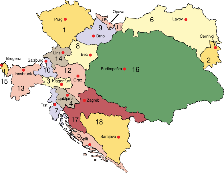
Hrvatski: Austro-Ugarska: Cislajtanija: 1. Bohemija, 2. Bukovina, 3. Koruška, 4. Kranjska, 5. Dalmacija, 6. Galicija i Lodomerija, 7. Austrijsko primorje, 8. Donja Austrija, 9. Moravska, 10. Salzburg, 11. Austrijska Šleska, 12. Štajerska, 13. Tirol, 14. Gornja Austrija, 15. Vorarlberg; Translajtanija: 16. Ugarska 17. Hrvatska i Slavonija; austro-ugarski kondominij: 18. Bosna i Herzegovina |
||
| Date | |||
| Source | Austria-Hungary map.svg | ||
| Author |
|
||
| Permission (Reusing this file) |
|
||
| Other versions |
Derivative works of this file:
|
| This is a retouched picture, which means that it has been digitally altered from its original version. The original can be viewed here: Austria-Hungary map.svg:
|
Original upload log
This image is a derivative work of the following images:
- File:Austria-Hungary_map.svg public domain
File history
Click on a date/time to view the file as it appeared at that time.
| Date/Time | Thumbnail | Dimensions | User | Comment | |
|---|---|---|---|---|---|
| current | 11:53, 6 March 2017 | | 783 × 605 (334 KB) | IvanOS | User created page with UploadWizard |
File usage
The following page uses this file:
Global file usage
The following other wikis use this file:
- Usage on ar.wikipedia.org
- Usage on en.wikipedia.org
- Usage on hr.wikipedia.org