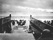
Platja d'Omaha (Q464257)
Salta a la navegació
Salta a la cerca
nom en clau d'un dels cinc punts d'invasió en el desembarcament de Normandia (1944)
- Omaha Beach
| Llengua | Etiqueta | Descripció | També conegut com a |
|---|---|---|---|
| català | Platja d'Omaha |
nom en clau d'un dels cinc punts d'invasió en el desembarcament de Normandia (1944) |
|
| anglès | Omaha Beach |
1944 one of the five sectors of the Allied invasion of German-occupied France |
|
Declaracions
Omaha Beach
0 referències
Identificadors
Enllaços de llocs
Viquipèdia(39 entrades)
- afwiki Omaha-strand
- arwiki شاطئ أوماها
- arzwiki شط اوماها
- brwiki Omaha Beach
- cawiki Platja d'Omaha
- cebwiki Omaha Beach (lapyahan sa Pransiya)
- cswiki Omaha Beach
- dawiki Omaha Beach
- dewiki Omaha Beach
- elwiki Παραλία Ομάχα
- enwiki Omaha Beach
- eswiki Playa de Omaha
- fawiki ساحل اوماها
- frwiki Omaha Beach
- fywiki Omaha Beach
- hewiki חוף אומהה
- hrwiki Plaža Omaha
- huwiki Omaha partszakasz
- idwiki Pantai Omaha
- itwiki Omaha Beach
- jawiki オマハ・ビーチ
- kowiki 오마하 해변
- liwiki Omaha Beach
- lmowiki Omaha Beach
- mrwiki ओमाहा बीच
- nlwiki Omaha Beach
- nowiki Omaha Beach
- plwiki Plaża Omaha
- ptwiki Praia de Omaha
- rowiki Plaja Omaha
- ruwiki Омаха-Бич
- slwiki Obala Omaha
- svwiki Omaha Beach
- tawiki ஒமாகா கடற்கரை
- thwiki หาดโอมาฮา
- trwiki Omaha Sahili
- ukwiki Плацдарм «Омаха»
- viwiki Bãi Omaha
- zhwiki 奥马哈海滩
Viquillibres(0 entrades)
Viquinotícies(0 entrades)
Viquidites(0 entrades)
Viquitexts(0 entrades)
Viquiversitat(0 entrades)
Wikivoyage(1 entrada)
- dewikivoyage Omaha Beach und Pointe du Hoc

