File:Mangkhut 2018-09-12 0150Z.png
Jump to navigation
Jump to search

Size of this preview: 450 × 600 pixels. Other resolutions: 180 × 240 pixels | 360 × 480 pixels | 576 × 768 pixels | 768 × 1,024 pixels | 1,800 × 2,400 pixels.
Original file (1,800 × 2,400 pixels, file size: 7.62 MB, MIME type: image/png)
Summary
| Description |
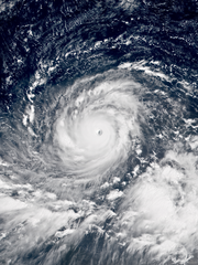
English: Typhoon Mangkhut over the Philippine Sea at peak intensity on September 12, 2018. |
| Date | |
| Source | RAMMB/CIRA SLIDER |
| Author | AHI image captured by the Japan Meteorological Agency’s Himawari-8 satellite |
| Camera location | | View this and other nearby images on: OpenStreetMap |
|---|
Licensing
This image is in the public domain because it contains materials that originally came from the U.S. National Oceanic and Atmospheric Administration, taken or made as part of an employee's official duties.
|
File history
Click on a date/time to view the file as it appeared at that time.
| Date/Time | Thumbnail | Dimensions | User | Comment | |
|---|---|---|---|---|---|
| current | 10:32, 12 September 2018 | | 1,800 × 2,400 (7.62 MB) | Meow | User created page with UploadWizard |
File usage
There are no pages that use this file.
Global file usage
The following other wikis use this file:
- Usage on arz.wikipedia.org
- Usage on en.wikipedia.org
- Usage on es.wikipedia.org
- Usage on nl.wikipedia.org
- Usage on nl.wikinews.org
- Usage on ru.wikipedia.org
- Usage on tl.wikipedia.org