File:Bundestagswahl 2017 Erststimmen WDQS.png
Jump to navigation
Jump to search
Size of this preview: 466 × 599 pixels. Other resolutions: 187 × 240 pixels | 373 × 480 pixels | 597 × 768 pixels | 796 × 1,024 pixels | 1,920 × 2,469 pixels.
Original file (1,920 × 2,469 pixels, file size: 3.71 MB, MIME type: image/png)
Summary
| Description |
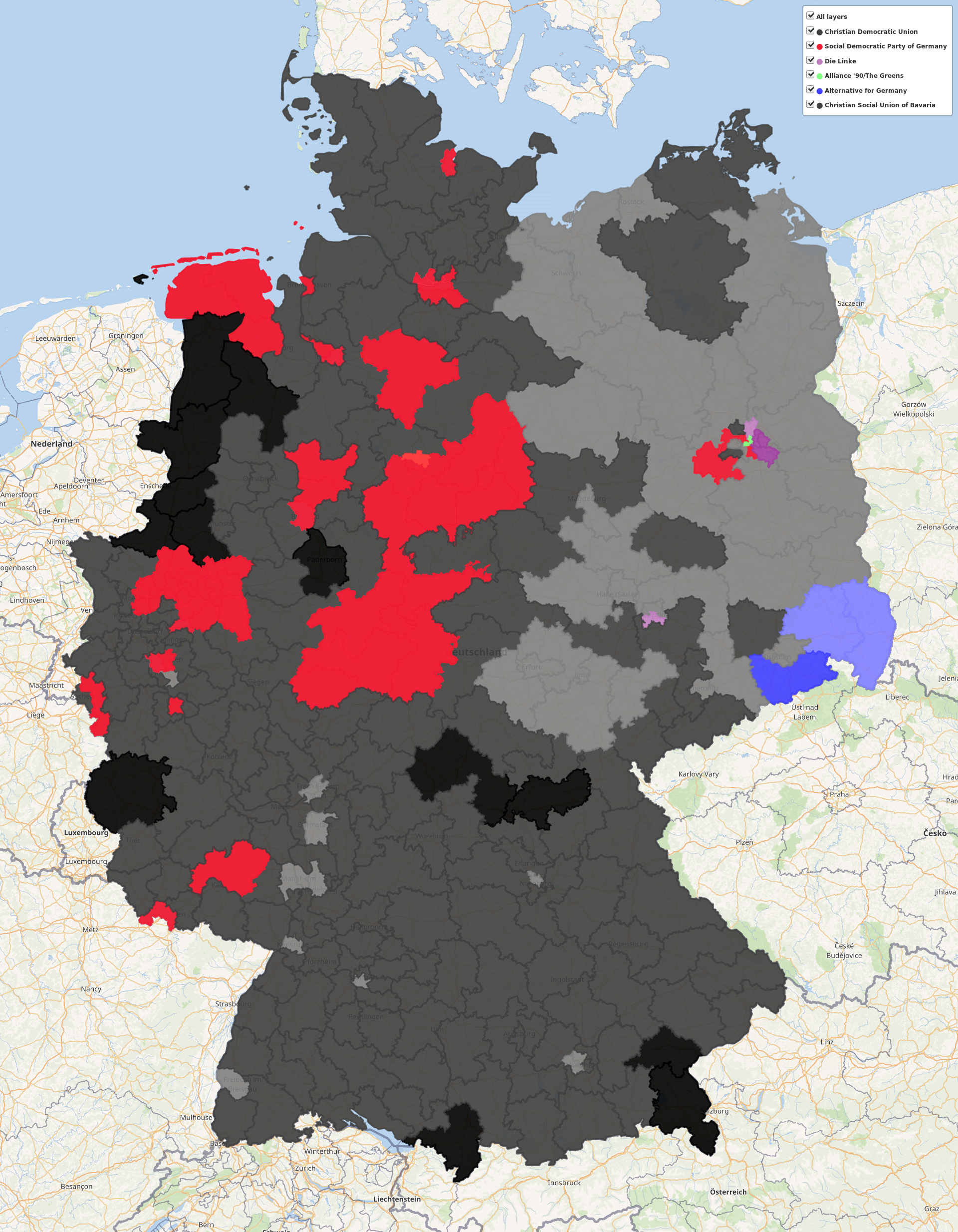
Deutsch: Karte der Wahlkreise bei der Bundestagswahl 2017, eingefärbt nach Erststimmenergebnis. Die Sättigung der Farbe gibt den Stimmenanteil der siegreichen Partei an, in drei Stufen: <30%, 30% – 50%, ≥50%.
Die Umrisse der Wahlkreise stammen von Wikimedia Commons, die Wahlergebnisse von Wikidata. Live-Karte auf dem Wikidata Query ServiceEnglish: Map of electoral districts for the German federal election 2017, colored by results in the primary (direct) vote. The saturation of the color indicates the winning party’s percentage in votes, in three tiers: <30%, 30% – 50%, ≥50%.
The geoshapes of the electoral districts are from Wikimedia Commons, the election results from Wikidata. Live map on the Wikidata Query Service |
| Date | |
| Source | Own work |
| Author |
Licensing
I, the copyright holder of this work, hereby publish it under the following license:
This file is licensed under the Creative Commons Attribution-Share Alike 4.0 International license.
- You are free:
- to share – to copy, distribute and transmit the work
- to remix – to adapt the work
- Under the following conditions:
- attribution – You must give appropriate credit, provide a link to the license, and indicate if changes were made. You may do so in any reasonable manner, but not in any way that suggests the licensor endorses you or your use.
- share alike – If you remix, transform, or build upon the material, you must distribute your contributions under the same or compatible license as the original.
| This work contains information from OpenStreetMap, which is made available under the Open Database License (ODbL).
The ODbL does not require any particular license for maps produced from ODbL data. Prior to 1 August 2020, map tiles produced by the OpenStreetMap Foundation were licensed under the CC-BY-SA-2.0 license. Maps produced by other people may be subject to other licences. |
File history
Click on a date/time to view the file as it appeared at that time.
| Date/Time | Thumbnail | Dimensions | User | Comment | |
|---|---|---|---|---|---|
| current | 13:01, 13 April 2018 | | 1,920 × 2,469 (3.71 MB) | Lucas Werkmeister (WMDE) | I took the screenshot again (same resolution), removing most of the controls. It looks like there were some minor improvements to the geoshapes as well in the meantime. |
| 11:52, 29 October 2017 |  | 1,920 × 2,469 (5.74 MB) | Lucas Werkmeister (WMDE) | User created page with UploadWizard |
File usage
The following 3 pages use this file: